
Where is Malaysia Airlines Flight MH370?
Some folks have been asking us if we can help find the Malaysia Airlines jetliner that disappeared early into a flight from Kuala Lumpur to Beijing. Many news reports state the Boeing 777 vanished from radar “about 2 hours” into the planned 6-hour flight to Beijing, but that would have put the jet well over land, near the city of Ban Khoun Kham in the rugged terrain of southern Laos (see our admittedly simple map-based calculations below).
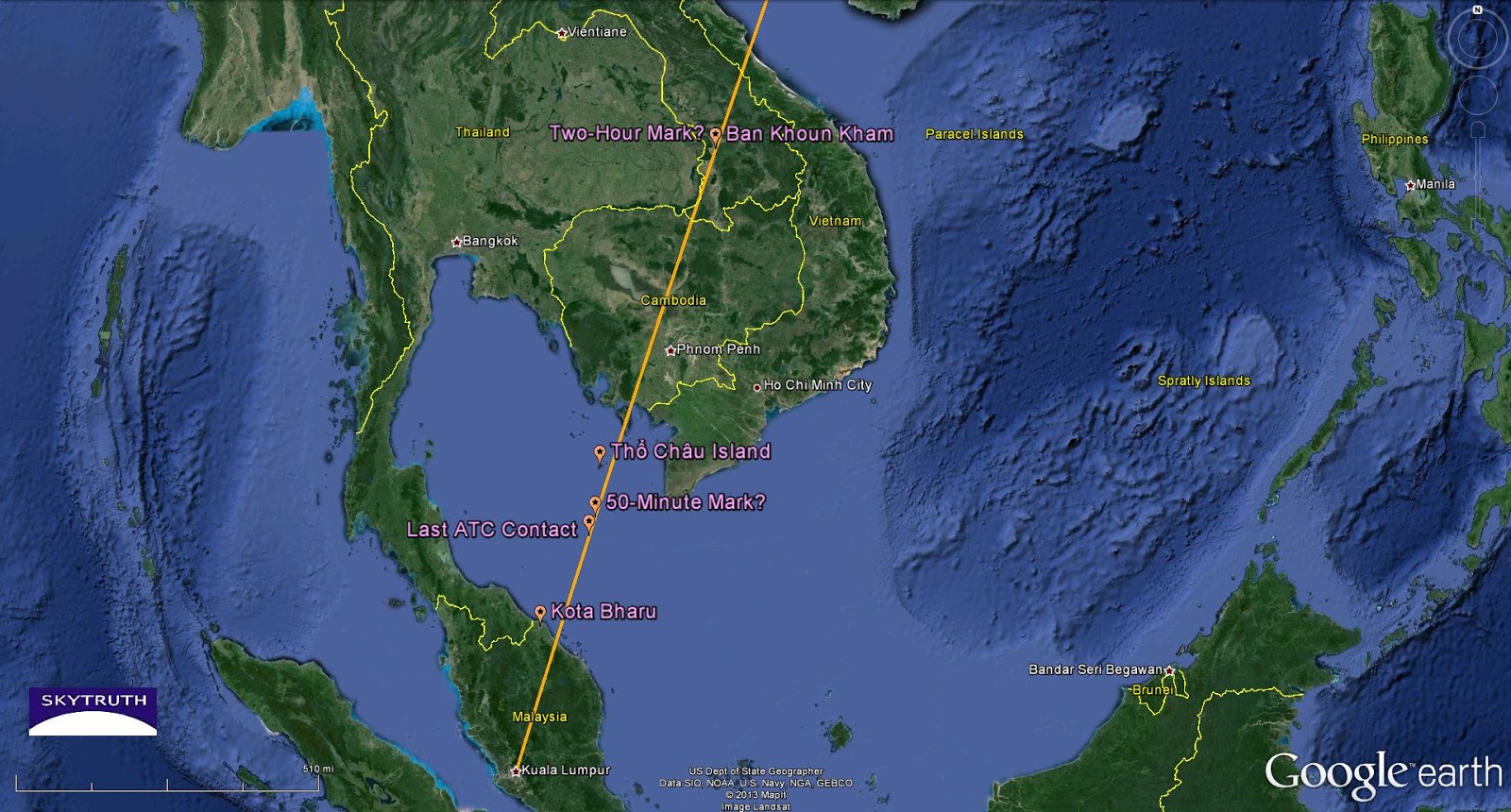
Map showing our guess at the approximate path of Flight MH370 (orange line) with significant waypoints from various media reports, and from our calculations based on the flight distance and scheduled flight time.
A BBC News report gives more precise timing (thank you, BBC!). Flight MH370 took off at 16:41 GMT on Friday, March 7 (that’s 41 minutes past midnight, early Saturday morning local time). The last contact with air traffic controllers was about 50 minutes later, at 17:30. Based on a Malaysia Airlines route map from their website, and a scheduled travel time of about 6 hours, we think that last contact occurred about 83 nautical miles west-southwest of the tip of Vietnam, in the mouth of the Gulf of Thailand. That’s not far from where a couple of small, orange-tinged, possible oil slicks were sighted, although samples of those slicks reportedly did not match the jet’s fuel. It’s also roughly where airline officials placed the last contact with air traffic controllers, described as being about 120 nautical miles from the coastal Malaysian city of Kota Bharu.

Detail from above, including our estimated location of small oil slick sightings reported in the media.
So, we searched the free archive of low-resolution, twice-daily NASA/MODIS satellite images for this area, to see if anything useful might turn up.
Short answer: as far as we can tell, no.
Images for the past few days are somewhat hazy and cloudy, particularly the Terra image taken at 2:50 GMT on March 8, about 8-1/2 hours after controllers lost contact. The March 8 Terra and Aqua images also suffer from big gaps in coverage that unfortunately fall right over part of the expected flight path out of Malaysia (gaps in MODIS coverage are not at all uncommon, so conspiracy theorists, take a deep breath). Strong sets of jet contrails are visible on the images from March 8 and March 9, but those are well offshore and parallel to the east coast of Vietnam, and long after Flight MH370 left Kuala Lumpur.
One of the last MODIS images taken BEFORE Flight MH370 took off is a Terra image captured at 03:50 GMT on March 7, about 13 hours before departure. I’ve included this because it shows a few small oil slicks in the Gulf of Thailand. One is clearly bilge-dumping from a passing vessel, something that is unfortunately common in the waters around Vietnam, as our work with radar satellite images has shown.

Detail from a MODIS/Terra image of Gulf of Thailand, taken about 13 hours before Flight MH370 departed Kuala Lumpur. Estimated flight path show as bold orange line. Several small oil slicks are annotated.
Radar imagery would be very helpful for this search, because it’s much better able to show small oil slicks than this low-res MODIS stuff. But, because NASA doesn’t operate a radar imaging satellite, we have to buy radar imagery from other sources; and the odds of an image having been acquired in the right place and time to be helpful in this case are pretty slim. But if anyone knows otherwise, please chime in with a comment or send us an email.

The oil is on the right of its original path. Wouldn't that mean the plane would have turned from its original course?
Ace – the oil slicks shown in our MODIS/Terra image don't have anything to do with MH370, because that satellite image was taken half a day before the flight took off. We included it to show that oil slicks are frequently observed in this area, from shipping and offshore oil and gas activity.
It is a 'ghost flight'. There are several possibilities of what happen to flight MH370. In such parts of the world where mystery surrounds the ocean and the mountains of Asia. It is clear that the two main possibilities are: Hijack and crash. The investigations have diverted from the original plane's flying path which clearly suggest hijack. A black box in the Indian Ocean is such a far fetched of an idea to be believed. This probably will remain a mystery for some time. Thanks for your good pictures they are very helpful. My thoughts and prayers to all who are or have been involved in this apparent tragic mystery.